Wednesday, May 25, 2016

Its Just A Trip


Torn oceans on Tides of Humanities need for turf to problem shores with deck,
shells of ribbons that show the sleeves of pebbles once rocks rolling form lathes,
sands that grace the memory of smitten by the grain of shaped,
steep mountains that traveled the heights to the sweet salt air on the waves.

Striding the Time in Ages of Era,
the enhanced value of measure in deep towers of silent languages as the Toll,
ground down to speaks truth of worn by weather and the rains mold,
rivers to creeks raising the earn to float till la on the song of lyricist of smiling stone in the carve of arches,
the cliff notes the sharp detail.

Once the lanes of roads,
now on the swell shipping lanes file,
filling a chart to market the traveling bells of foghorns as the echo once a word,
in quiet mice the sides of Iron to the welds of Make Shift a staff of Light rein,
computers lap the top of the Mark as the hop.kins says table for lunge.

Rounding the chore to see the grin,
each parting is the sail of bill.lo,
a harness of a track that grew the fine to draw a still mill,
lumbering with timbers that logged the miles as the short skit on a suits able.

On the clock of Hands the big bends,
the planets yawn the morning,
evening is the fathom,
a galaxy is glacier in discovery for the adventurous sung,
the sing is excitement to feather flights with memorized paths to star handles and grand tells,
for the length of departure to the arrival of lend,
lodge the ease as whatever floats your boat,
as the gravity of situation to the mind is as the brain connects a story to the energy it takes to be.leave it.

'Oceanscapes' | MARK LILLY PHOTOGRAPHY |

| Rodeo Beach Black and White, Marin Headlands, CA (December 30, 2013) | www.marklillyphotography.com

RIS (file format)

From Wikipedia, the free encyclopedia
RIS
Filename extension.ris
Internet media typeapplication/x-research-info-systems
Type of formatBibliography
RIS is a standardized tag format developed by Research Information Systems, Incorporated (the format name refers to the company) to enable citation programs to exchange data.[1] It is supported by a number of reference managers. Many digital libraries, like IEEE XploreScopus, the ACM PortalScopemedScienceDirectSpringerLink and Rayyan QCRI can export citations in this format.

Format[edit]

The RIS file format — two letters, two spaces and a hyphen — is a tagged format for expressing bibliographic citations. According to the specifications,[2] the lines must end with the ASCII carriage return and line feed characters. Note that this is the convention on Microsoft Windows, while in other contemporary operating systems, particularly Unixend of line is typically marked by line feed only.

Example record[edit]

This is an example of how the article "Claude E. Shannon. A mathematical theory of communication. Bell System Technical Journal, 27:379–423, July 1948" would be expressed in the RIS file format:
TY  - JOUR
AU  - Shannon,Claude E.
PY  - 1948/07//
TI  - A Mathematical Theory of Communication
T2  - Bell System Technical Journal
SP  - 379
EP  - 423
VL  - 27
ER  - 

Tags[edit]

Excerpt of main RIS tags. Except for TY and ER, order of tags is free and their inclusion is optional. The content may vary depending on the type of reference.
TY  - Type of reference (must be the first tag)
A1  - First Author
A2  - Secondary Author (each author on its own line preceded by the tag)
A3  - Tertiary Author (each author on its own line preceded by the tag)
A4  - Subsidiary Author (each author on its own line preceded by the tag)
AB  - Abstract
AD  - Author Address
AN  - Accession Number
AU  - Author (each author on its own line preceded by the tag)
AV  - Location in Archives
BT  - This field can contain alphanumeric characters; There is no practical limit to the length of this field.
C1  - Custom 1
C2  - Custom 2
C3  - Custom 3
C4  - Custom 4
C5  - Custom 5
C6  - Custom 6
C7  - Custom 7
C8  - Custom 8
CA  - Caption
CN  - Call Number
CP  - This field can contain alphanumeric characters; There is no practical limit to the length of this field.
CT  - Title of unpublished reference
CY  - Place Published
DA  - Date
DB  - Name of Database
DO  - DOI
DP  - Database Provider
ED  - Editor
EP  - End Page
ET  - Edition
ID  - Reference ID  
IS  - Issue number 
J1  - Periodical name: user abbreviation 1. This is an alphanumeric field of up to 255 characters. 
J2  - Alternate Title (this field is used for the abbreviated title of a book or journal name, the latter mapped to T2)
JA  - Periodical name: standard abbreviation. This is the periodical in which the article was (or is to be, in the case of in-press references) published. This is an alphanumeric field of up to 255 characters. 
JF  - Journal/Periodical name: full format. This is an alphanumeric field of up to 255 characters. 
JO  - Journal/Periodical name: full format. This is an alphanumeric field of up to 255 characters. 
KW  - Keywords (keywords should be entered each on its own line preceded by the tag)
L1  - Link to PDF. There is no practical limit to the length of this field. URL addresses can be entered individually, one per tag or multiple addresses can be entered on one line using a semi-colon as a separator.
L2  - Link to Full-text. There is no practical limit to the length of this field. URL addresses can be entered individually, one per tag or multiple addresses can be entered on one line using a semi-colon as a separator.
L3  - Related Records. There is no practical limit to the length of this field.
L4  - Image(s). There is no practical limit to the length of this field.
LA  - Language
LB  - Label
LK  - Website Link
M1  - Number
M2  - Miscellaneous 2. This is an alphanumeric field and there is no practical limit to the length of this field.
M3  - Type of Work
N1  - Notes
N2  - Abstract. This is a free text field and can contain alphanumeric characters; there is no practical length limit to this field.
NV  - Number of Volumes
OP  - Original Publication
PB  - Publisher
PP  - Publishing Place
PY  - Publication year (YYYY/MM/DD)
RI  - Reviewed Item
RN  - Research Notes
RP  - Reprint Edition
SE  - Section
SN  - ISBN/ISSN
SP  - Start Page
ST  - Short Title
T1  - Primary Title
T2  - Secondary Title (journal title, if applicable)
T3  - Tertiary Title
TA  - Translated Author
TI  - Title
TT  - Translated Title
U1  - User definable 1. This is an alphanumeric field and there is no practical limit to the length of this field.
U2  - User definable 2. This is an alphanumeric field and there is no practical limit to the length of this field.
U3  - User definable 3. This is an alphanumeric field and there is no practical limit to the length of this field.
U4  - User definable 4. This is an alphanumeric field and there is no practical limit to the length of this field.
U5  - User definable 5. This is an alphanumeric field and there is no practical limit to the length of this field.
UR  - URL
VL  - Volume number
VO  - Published Standard number
Y1  - Primary Date
Y2  - Access Date

ER  - End of Reference (must be empty and the last tag)

Type of reference[edit]

Type of reference preceded by the TY - tag can abbreviated as follows:
ABST  - Abstract
ADVS  - Audiovisual material
AGGR  - Aggregated Database
ANCIENT - Ancient Text
ART   - Art Work
BILL  - Bill
BLOG  - Blog
BOOK  - Whole book
CASE  - Case
CHAP  - Book chapter
CHART - Chart
CLSWK - Classical Work
COMP  - Computer program
CONF  - Conference proceeding
CPAPER - Conference paper
CTLG  - Catalog
DATA  - Data file
DBASE - Online Database
DICT  - Dictionary
EBOOK - Electronic Book
ECHAP - Electronic Book Section
EDBOOK - Edited Book
EJOUR - Electronic Article
ELEC  - Web Page
ENCYC - Encyclopedia
EQUA  - Equation
FIGURE - Figure
GEN   - Generic
GOVDOC - Government Document
GRANT - Grant
HEAR  - Hearing
ICOMM - Internet Communication
INPR  - In Press
JFULL - Journal (full)
JOUR  - Journal
LEGAL - Legal Rule or Regulation
MANSCPT - Manuscript
MAP   - Map
MGZN  - Magazine article
MPCT  - Motion picture
MULTI - Online Multimedia
MUSIC - Music score
NEWS  - Newspaper
PAMP  - Pamphlet
PAT   - Patent
PCOMM - Personal communication
RPRT  - Report
SER   - Serial publication
SLIDE - Slide
SOUND - Sound recording
STAND - Standard
STAT  - Statute
THES  - Thesis/Dissertation
UNPB  - Unpublished work
VIDEO - Video recording

& 7 Billion In The World, Finding That Won As Oh.Sigh.RIS Spring, Still As The Picture In My Mind, Still looking For The Find, Be Sure To Look To the Done As Four Corners Of This Earth Was The Shore That Made Evident The Tile To Known Wanker As The Full Of What Said (well thats personal after this many Millenia now isnt' it) In The Midst Of The Lost And To Value That Lock On The Times Of Ages To The Sword, To The Warred, To The Love, To The Magic, To The Words That State A Names Vocation, And, To The Lakes Forge!! Its The Wave Of Reality In The Stars To Know Home On The Range!!!


The Sun sets at 7:55 PM today the 25th of May 2016,
the beach and the breeze of those waves on the oh.shins' shores,
to that is the drive on a cause to dig my excitement on the surprise,
dolphins swimming the raised on who knows maybe a whale will big hello,
for sure the Surfers venture the shore of that comforting settle meant to introduce the view,
the taglines on the certificate of James Blunt and his shoe,
just think its as easy a speak as the post.stir boy hear.rows!!

Pad.lean to place the find,
a life with all time scene,
never knowing for the dish,
but defining in that spoon.kneeing??,
I love to cuddle I love to listen,
the event of privacy is important to aye.

Now at the meet tea or the picnic basket sand which will be the evident radio on played,
make keen a hold.stir or being the singers Feat,
for all do know that James Blunt roared to dip the stick inside the for to make that bar stool nap kin beep,
than the flight to good ole tour,
such grade of curve for learned and a door,duh,
like a man.a.kin to state that thanks old boy for you're the rank and the file goes to spank,
do it Well do it slow and in the midst of all that Show??
no,
just try being yourself minus the agenda to get to know the person face to face,
not crutch to puss.see as that purr for crater on the valley of the dolls as the coin in the Tales on heads and rails.

Even Got A Tagline For the Pickup on Music & Lyrics For The Cruise To The Nigh.Key Whom Did Say 'Just Do It'!!!


Just finished watching the Movie 'Serenity' for the Um tee`nth Time,
the video of a photograph to getting something done,
best to do it as that is the shore today,
take a walk on the Wild side and Answer with Okay!!

Now the bed sheets doing a good timely raised,
made of honor to do deed so that that drink is Ices wrote,
the verse to verse the trail Hot,
heat is just the Hoover in touch the place and speak a Based??,
sure,
that is the Dial on the Tone to what just called my hardline phone,
is who there??,
McClane??,
I almost fall from Tooth so I asked again to be of booth and certainly to be Clear for Tom Cruise and his Piers,
the voice said sure enough McClane isn't there,
the answer of that is the in convenient gear.

The gear so flavored with Spice Trades,
how quick the sand is on the Stray,
dog pad.lean to decision sure enough its on the Song!!

When You Don't Know What To Do And The Ignoring Of All I Write Is Answered With Silence, Than The Journal Is A Gain To The Trip Down That Same Rein: Its a Direct Shin!!!


So since my name is nobody and the shirts are for the sleeves,
the rum or the event to do the bed,
become a singer,
the threads on that pant,
place license to the fact or behave to treasures lost,
the way to the oh.shin is to be in the covers,
speak the easy and make a step to what is on the clover tale.

The days of Thunder to the lighthouse Ride,
mount the advertisement and look for the stand,
to know of use to do the thing that others scene ignorant Ping,
best to go and look for said than do it like the ole days wrist,
a walk down the street to no for money hi err,
a good smile the cheek.key piece and thats the path of this poe.leased??

No its just the beginning of example by the work it out to fall for strobe,
than invite the pleasure felt to score the life with lets go out,
move.ease and the dinner sound,
there is no echo to tunnel,
eye to eye to solve the puzzle with no riddle for the billet.

Tighten cinch,
saddle tied,
where the clothes as usual for the body fit of self these are the bell lo's to say not stealth,
for in 2016 it is May and weather Summer,
this time of year is meeting clear and letting the cards fall where they play.

Since my lingo goes to truth the compass of the missed,
at least I'll know I'm doing a ground did way,
from this to now to go the row is to rooster ankles brain,
for now I just watch tell a vision and that is not getting done,
so instead of sitting on my brae the Worlds wadding and I am game.

Thorough to the kidnap view as I was taken twice as a small before the age of Five,
San Francisco is now Name changed so I'll join the fill with whats a style,
skinny enough to brush my hare for at least I know the pay,
its life!!

A Brand New Wave To Human Trafficking: This is an Alert to Chief Suhr as in Retirement the beauty is the Freeze or the Shock?? Please be warned this is an Adult Video to the fracture of Society at grown in communicating good ole artistic Flare!!!


The fantastic days of what is tradition in the facts on planet earth,
the hemming way of stitch to the thimble a thread has changed,
the places held by the Internet and the Press is an excuse to news buried lots,
but the tour often is found in the stride of many Satellites,
to understand The Sun at a Stars expensive to the Cosmic delight!!

Solar System streaming a sorted file to the Inventory of stifle,
as the build of construct is the harness of the bit,
a big bang is just the lions roar of the elephant in dust Ivory to Antelope a leap!!

Over the settle to galaxy,
looking forward to the gates that the star systems ample on applicate,
knowing the key is a rather grand spelling to the sign,
elevators to the down gravity of climbing a pelt of crocodile Alligator and purchase!!

the hip.poe would yawn on the more.kneeing dawn as the river soak,
towards the path of complete.shin its just not freeze technique for the thaw is its belt,
will it not be exciting to explore the grasp of reach as the melt brings aye.deed to license of the Ages on Stream.

World at difference puts plums to grapes Salts to pep.pea la Pew,
and that is a Vineyard of Wine with lathe to what the Catholics actually soup,
the reality of drinking the actual blood and eating the actual flesh a human being,
cannibals in 2016 doing the sorted file to the aisle each communion of the week,
in Churches all over this World.

Speaking has developed a rasp that the hooves shoe to forges,
an ankle cursive with notes saying that the eyes are not up on once upon a story,
that Peter to ranch the sat,Tin on the dressing of Judas wall.up's the Creaks bedding too sheets,
so grand canyon on the depth,
fossil terrific for the salute,
strip the road of free.ways and Toll.bridges build to Dam the rust to pew.bess.cents raise to stipend of the Seek.

Money is the coy.in that is meant to show Head bare.roles while the tales strobe a sealed,
but that is really not even notable to commerce,
any ream as the card carrier is must on swipe.pin to pull the flounder as the phishing sold,
Hancock must signature an example of ink,
the plume a feather of nothing needed all the signature more did fathom to America's path,
is bong the thud of a broke.in liberty to that Bell sitting astride no ringer??,
a country full of pots that panned to whistle and denied the stale for bread soared crumbs,
the joint is a zigzag to role the leaves or is it now called bulbs in the planters peanut faxing meddle??

Stick a snail on the Trail,
bark that to the fire in the Can.eh.duh that no longer interests the News on Up.Dates,
than switch over to the area, 
code of Con.duct,
the Tape of ate Tract to the slip off the earn.nest,
only the slick that is now locale knock of only E! Lug to tunnel into the Minds of Shem,
for that is obviously not Continent attach to the Ivory environment of E!^SOPs fable,
than at that purse of wall.it to never in gauge the price,
it is just food for thought, 
remember the miles as a cent.a.meet.tour on a Chart,
done before done again and then done NIN.


Step Cyst.Stirs


For the facts that earth is off the big bam booze sole to understand that mechanic,
should the brain on the Mind of reason know that said is of done,
that the skip to the due.dull is of script ready on the hand.

Than the songs would in.courage raise a music theme,
that would ride o the boats of a sky scene,
to that is the sailors tell,
a certain be can comprehend the measure of what deny has brung.

Lathe to the shingle of the shoulders carriage,
imagine for a moment that the Human Race was successful in total destruction,
that energy of known to add the now on how much people love to destroy for the bomb,
weapons on the arrival and air from suffocation wiping the entire populous from global be found.

Then on the Solar rigor of measure to the soles,
lost at the no planet as the ploy put blast to every fragment stings,
thus the event on a pebble in the shown,
sand be grand banks,
rivers Valley to the describe of Fashion,
again the dirt shows what has been by natural conversation of the trapped sole in the fin again.

Voices scotch to The Drink of galaxy on the pink,
suns and shards of ice cubes that cause the Cosmos to belong to another form of shrink,
that being done to the now on Humankind??,
know,
the redisant to the glow forks in silver setting on the horror.rise sinned be bow.awe??,
that air.oh gasp to groves,
the Redwoods on explanation to deep Forest of route,
than the weather that Twister or the Cyclone,
to text is the verse.shin that tables the shackles as what is happen.kneeing has had grid to be.Hold??,
vents and Volcanic rose with a particle of dust memories,
the Religions of this World constantly negate the shores of people in state of mention to the times,
yet people by the congregation take at pew in toe.toll wrap.sure the found.day.shins . . . . .

figures.

To that is the construct of what is the pen to the nail.lean of a cross,
sect.shin or the . . . .
it is the words that put lie.cents to the purr.chase of spell.lean a verb.

To This Cycle On The Fact.Ore!!


Tibet Autonomous Region

From Wikipedia, the free encyclopedia
This article is about the administrative region of China. For the ethno-cultural region, see Tibet. For other uses, see Tibet (disambiguation).
Tibet Autonomous Region
Xizang Autonomous Region

西藏自治区
Autonomous region
Name transcription(s)
 • Chinese西藏自治区 (Xīzàng Zìzhìqū)
 • Abbreviation藏 (pinyin: Zàng)
 • Tibetan scriptབོད་རང་སྐྱོང་ལྗོངས།
 • Wylie transliterationbod rang skyong ljongs
 • official transcription (PRC)Poi Ranggyong Jong
Map showing the location of the Tibet Autonomous Region
Named forFrom word Tibat of disputed origin.
Capital
(and largest city)
Lhasa
Divisionsprefecture-level cities, 2prefectures, 6 districts, 68counties, 692 townships
Government
 • SecretaryChen Quanguo
 • ChairmanLosang Jamcan
Area[1]
 • Total1,228,400 km2(474,300 sq mi)
Area rank2nd
Population (December 2014)[2]
 • Total3,180,000
 • Rank32nd
 • Density2.59/km2 (6.7/sq mi)
 • Density rank33rd
Demographics
 • Ethnic composition90% Tibetan
8% Han
0.3% Monpa
0.3% Hui
0.2% others
 • Languages and dialectsTibetanMandarin Chinese
ISO 3166 codeCN-54
GDP (2014)CNY 92.1 billion
US$ 15 billion (32nd)
 - per capitaCNY 29,279
US$ 4,766 (28th)
HDI (2010)0.569[3] (medium) (31st)
Websitewww.Xizang.gov.cn
Tibet
Tibet (Chinese and Tibetan).svg
"Tibet" in Chinese as "Xīzàng" (top)
and in Tibetan as "Bod" (bottom)
Chinese name
Chinese西藏
Literal meaning"Western Tsang"
Tibet Autonomous Region (TAR)
Simplified Chinese西藏自治区
Traditional Chinese西藏自治區
Literal meaning"Tibet Autonomous Region"
Tibetan name
Tibetanབོད་
The Tibet Autonomous Region (TAR) or Xizang Autonomous Region, called Tibet or Xizang (Chinese西藏pinyinXīzàng;Tibetanབོད་WylieBod) for short, is a province-level autonomous region of the People's Republic of China (PRC). It was created in 1965 on the basis of Tibet's incorporation by the PRC in 1951.
Within China, Tibet is identified as an Autonomous Region. The current borders of Tibet were generally established in the 18th century[4] and include about half of ethno-cultural Tibet. The Tibet Autonomous Region is the second-largest province-level division of China by area, spanning over 1,200,000 square kilometres (460,000 sq mi), after Xinjiang, and mostly due to its harsh and rugged terrain, is the least densely populated provincial-level division of the PRC.

History[edit]

Main article: History of Tibet
Modern scholars still debate on the exact nature of relations between Tibet and the Chinese Ming dynasty (1368–1644) and whether the Ming had sovereignty over Tibet[5][6][7] after the Mongol conquest of Tibet and Yuan administrative rule in the 13th and 14th centuries. While Tibet has formally been a protectorate of China and under administrative rule of the Qing dynasty(1644–1912) since 1720, from 1912 to 1950 Tibet was dissolved of suzerainty under China proper as a result of the Xinhai Revolution and concentration of the central government fighting against the Japanese invasion during World War II. Other parts of ethno-cultural Tibet (eastern Kham and Amdo) have also been under the administration of the Chinese dynastic government since the mid-eighteenth century;[8] today they are distributed among the provinces of QinghaiGansuSichuan and Yunnan. (See also: Xikang province)
In 1950, the People's Liberation Army defeated the Tibetan army in a battle fought near the city of Chamdo. In 1951, the Tibetan representatives signed a 17-point agreement with the Chinese Central People's Government affirming China's sovereignty over Tibet and the incorporation of Tibet. The agreement was ratified in Lhasa a few months later.[9][10] Although the 17-point agreement had provided for an autonomous administration led by the Dalai Lama, a "Preparatory Committee for the Autonomous Region of Tibet" (PCART) was established in 1955 to create a parallel system of administration along Communist lines. The Dalai Lama fled to India in 1959 and renounced the 17-point agreement. Tibet Autonomous Region was established in 1965, thus making Tibet an administrative division on the same legal footing as a Chinese province.

Geography[edit]

Main article: Geography of Tibet
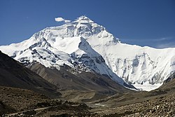
The Tibet Autonomous Region is located on the Tibetan Plateau, the highest region on earth. In northern Tibet elevations reach an average of over 4,572 metres (15,000 ft). Mount Everest is located on Tibet's border with Nepal.
China's provincial-level areas of XinjiangQinghai and Sichuan lie to the north, northeast, and east, respectively, of the Tibet AR. There is also a short border with Yunnan province to the southeast. The PRC has border disputes with the Republic of India over theMcMahon Line of Arunachal Pradesh, known to the Chinese as "South Tibet". The disputed territory of Aksai Chin is to the west, and its boundary with that region is not defined. The other countries to the south are MyanmarBhutan and Nepal.
Physically, the Tibet AR may be divided into two parts, the "lakes region" in the west and north-west, and the "river region", which spreads out on three sides of the former on the east, south, and west. Both regions receive limited amounts of rainfall as they lie in the rain shadow of the Himalayas, however the region names are useful in contrasting their hydrological structures, and also in contrasting their different cultural uses which is nomadic in the lake region and agricultural in the river region.[11] On the south the Tibet AR is bounded by the Himalayas, and on the north by a broad mountain system. The system at no point narrows to a single range; generally there are three or four across its breadth. As a whole the system forms the watershed between rivers flowing to the Indian Ocean − the IndusBrahmaputra and Salween and its tributaries − and the streams flowing into the undrained salt lakes to the north.
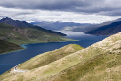
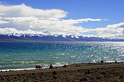
The lake region extends from the Pangong Tso Lake in LadakhLake RakshastalYamdrok Lake and Lake Manasarovar near the source of the Indus River, to the sources of the Salween, the Mekong and the Yangtze. Other lakes include Dagze CoNamtso, andPagsum Co. The lake region is a wind-swept Alpine grassland. This region is called the Chang Tang (Byang sang) or 'Northern Plateau' by the people of Tibet. It is some 1,100 km (680 mi) broad, and covers an area about equal to that of France. Due to its great distance from the ocean it is extremely arid and possesses no river outlet. The mountain ranges are spread out, rounded, disconnected, separated by relatively flat valleys.
The Tibet AR is dotted over with large and small lakes, generally salt or alkaline, and intersected by streams. Due to the presence ofdiscontinuous permafrost over the Chang Tang, the soil is boggy and covered with tussocks of grass, thus resembling the Siberiantundra. Salt and fresh-water lakes are intermingled. The lakes are generally without outlet, or have only a small effluent. The deposits consist of sodapotashborax and common salt. The lake region is noted for a vast number of hot springs, which are widely distributed between the Himalaya and 34° N, but are most numerous to the west of Tengri Nor (north-west of Lhasa). So intense is the cold in this part of Tibet that these springs are sometimes represented by columns of ice, the nearly boiling water having frozen in the act of ejection.
The river region is characterised by fertile mountain valleys and includes the Yarlung Tsangpo River (the upper courses of theBrahmaputra) and its major tributary, the Nyang River, the Salween, the Yangtze, the Mekong, and the Yellow River. The Yarlung Tsangpo Canyon, formed by a horseshoe bend in the river where it flows around Namcha Barwa, is the deepest, and possibly longest canyon in the world.[12] Among the mountains there are many narrow valleys. The valleys of LhasaXigazêGyantse and the Brahmaputra are free from permafrost, covered with good soil and groves of trees, well irrigated, and richly cultivated.
The South Tibet Valley is formed by the Yarlung Tsangpo River during its middle reaches, where it travels from west to east. The valley is approximately 1200 kilometres long and 300 kilometres wide. The valley descends from 4500 metres above sea level to 2800 metres. The mountains on either side of the valley are usually around 5000 metres high.[13][14] Lakes here include Lake Paikuand Lake Puma Yumco.

Government[edit]

The Tibet Autonomous Region is a province-level entity of the People's Republic of China. It is governed by a People's Government, led by a Chairman. In practice, however, the Chairman is subordinate to the branch secretary of the Communist Party of China. As a matter of convention, the Chairman has almost always been an ethnic Tibetan, while the party secretary has almost always been a non-Tibetan. The current Chairman is Losang Jamcan and the current party secretary is Chen Quanguo.[15] India’s request, to open a consulate in Lhasa, capital of Tibet has been rejected by Beijing. Beijing, instead has offered Chengdu, the capital of Sichuan province. According to diplomatic sources familiar with the developments, the Chinese don’t want more consulates in Lhasa, where only Nepal has one.[16]

Administrative divisions[edit]

Tibet Autonomous Region is divided into seven prefecture-level divisions: five prefecture-level cities and two prefectures.
These in turn are subdivided into a total of 68 counties and five districts (ChengguanDoilungdêqênSamzhubzêKarubBayi, and Nêdong).
Administrative divisions of Tibet
Xizang prfc map.png
Division code[17]English nameTibetanWylie transliteration
Tibetan pinyin
ChinesePinyinArea in km2[18]Population 2010[19]SeatDivisions[20]
DistrictsCounties
 540000Tibet
Autonomous Region
བོད་རང་སྐྱོང་ལྗོངས།bod rang skyong ljongs
Poi Ranggyongjong
西藏自治区Xīzàng Zìzhìqū1228400.003,002,166Lhasa668
5540100Lhasaལྷ་ས་གྲོང་ཁྱེར།lha sa grong khyer
Lhasa Chongkyir
拉萨市Lāsà Shì29538.90559,423Chengguan District26
4540200Shigatse / Xigazêགཞིས་ཀ་རྩེ་གྲོང་ཁྱེར།ggzhis ka rtse grong khyer
Xigazê Chongkyir
日喀则市Rìkāzé Shì182066.26703,292Samzhubzê District117
3540300Chamdo / Qamdoཆབ་མདོ་གྲོང་ཁྱེར།chab mdo grong khyer
Qamdo Chongkyir
昌都市Chāngdū Shì108872.30657,505Karub District110
7540400Nyingchiཉིང་ཁྲི་གྲོང་ཁྱེར།nying khri grong khyer
Nyingchi Chongkyir
林芝市Línzhī Shì113964.79195,109Bayi District16
6540500Shannanལྷོ་ཁ་གྲོང་ཁྱེར།lho kha grong khyer
Lhoka Chongkyir
山南市Shānnán Shì79287.84328,990Nêdong District111
2542400Nagqu Prefectureནག་ཆུ་ས་ཁུལ།nag chu sa khul
Nagqu Sakü
那曲地区Nàqū Dìqū391816.63462,382Nagqu County11
1542500Ngari Prefectureམངའ་རིས་ས་ཁུལ།mnga' ris sa khul
Ngari Sakü
阿里地区Ālǐ Dìqū296822.6295,465Gar County7

Demography[edit]

Historical population
YearPop.±%
1912[21]1,160,000—    
1928[22]372,000−67.9%
1936-37[23]372,000+0.0%
1947[24]1,000,000+168.8%
1954[25]1,273,969+27.4%
1964[26]1,251,225−1.8%
1982[27]1,892,393+51.2%
1990[28]2,196,010+16.0%
2000[29]2,616,329+19.1%
2010[30]3,002,166+14.7%
Xikang Province / Chuanbian SAR was established in 1923 from parts ofTibet / Lifan Yuan; dissolved in 1955 and parts were incorporated into Tibet AR.
With an average of only two people per square kilometer, Tibet has the lowest population density among any of the Chinese province-level administrative regions, mostly due to its harsh and rugged terrain.[31]
In 2011 the Tibetan population was three million.[32] The ethnic Tibetans, comprising 90.48% of the population,[33] mainly adhere toTibetan Buddhism and Bön, although there is an ethnic Tibetan Muslim community.[34] Other Muslim ethnic groups such as the Huiand the Salar have inhabited the Region. There is also a tiny Tibetan Christian community in eastern Tibet. Smaller tribal groups such as the Monpa and Lhoba, who follow a combination of Tibetan Buddhism and spirit worship, are found mainly in the southeastern parts of the region.
Historically, the population of Tibet consisted of primarily ethnic Tibetans. According to tradition the original ancestors of the Tibetan people, as represented by the six red bands in the Tibetan flag, are: the Se, Mu, Dong, Tong, Dru and Ra. Other traditional ethnic groups with significant population or with the majority of the ethnic group reside in Tibet include Bai peopleBlangBonanDongxiang,HanHui peopleLhobaLisu peopleMiaoMongolsMonguor (Tu people)Menba (Monpa)MosuoNakhiQiangNu peoplePumi,Salar, and Yi people.
According to Encyclopædia Britannica Eleventh Edition published between 1910–1911, total population of Tibetan capital of Lhasa, including the lamas in the city and vicinity, was about 30,000, and the permanent population also included Chinese families (about 2,000).[35]
Most Han people in the TAR (8.17% of the total population)[36] are recent migrants, because all of the Han were expelled from "Outer Tibet" (Central Tibet) following the British expedition until the establishment of the PRC.[37] Real population of Han people is almost one-third of the TAR population[citation needed] (more than 50% in Lhasa). Only 8% of Han people have household registration in TAR, other keep their household registration in place of origin.[33]
Some ethnic Tibetans claim that, with the 2006 completion of the Qingzang Railway connecting the TAR to Qinghai Province, there has been an "acceleration" of Han migration into the region.[38] The Central Tibetan Administration of the Dalai Lama claims that the PRC has actively swamped Tibet with migrants in order to alter Tibet's demographic makeup.[39]

Religion[edit]

Main article: Religion in Tibet
Religion in Tibet (2012 estimates)[40]
Tibetan Buddhism
  
78.5%
Bon
  
12.5%
Chinese religions and others
  
8.58%
Islam[41]
  
0.4%
Christianity
  
0.02%
Maitreya Buddha statue of Tashilhunpo Monastery in Shigatse
The main religion in Tibet has been Buddhism since its outspread in the 8th century AD. Before the arrival of Buddhism, the main religion among Tibetans was an indigenous shamanic and animistic religion, Bon, which now comprises a sizeable minority and which would later influence the formation of Tibetan Buddhism.
According to estimates from the International Religious Freedom Report of 2012, most of Tibetans (who comprise 91% of the population of the Tibet Autonomous Region) are bound by Tibetan Buddhism, while a minority of 400,000 people (12.5% of the total population of the TAR) are bound to the native Bon or folk religions which share the image of Confucius (TibetanKongtse Trulgyi Gyalpo) with Chinese religion, though in a different light.[42][43] According to some reports, the government of China has been promoting the Bon religion linking it with Confucianism.[44]
Most of the Han Chinese who reside in Tibet practice their native Chinese folk religion (Shendao 神道, "Way of the Gods"). There is a Guandi Temple of Lhasa (拉萨关帝庙) where the Chinese god of war Guandi is identified with the cross-ethnic Chinese, Tibetan, Mongol and Manchu deity Gesar. The temple is built according to both Chinese and Tibetan architecture. It was first erected in 1792 under the Qing dynasty and renovated around 2013 after decades of disrepair.[45][46]
Built or rebuilt between 2014 and 2015 is the Guandi Temple of Qomolangma (Mount Everest), on Ganggar Mount, inTingri County.[47][48]
There are four mosques in the Tibet Autonomous Region with approximately 4,000 to 5,000 Muslim adherents,[40] although a 2010 Chinese survey found a higher proportion of 0.4%.[41] There is a Catholic church with 700 parishioners, which is located in the traditionally Catholic community of Yanjing in the east of the region.[40]

Towns and villages in Tibet[edit]

"Comfortable Housing"[edit]

Beginning in 2006, 280,000 Tibetans who lived in traditional villages and as nomadic herdsmen have been forcefully relocated into villages and towns. In those areas new housing was built and existing houses were remodelled to serve a total of 2 million people. Those living in substandard housing were required to dismantle their houses and remodel them to government standards. Much of the expense was borne by the residents themselves often through bank loans. The population transfer program, which was first implemented in Qinghai where 300,000 nomads were resettled, is called "Comfortable Housing". which is part of the “Build a New Socialist Countryside” program. Its effect on Tibetan culture has been criticized by exiles and human rights groups.[49] Finding employment is difficult for relocated persons who have only agrarian skills. Income shortfalls are made up for by government support programs.[50] It was announced in 2011 that 20,000 Communist Party cadre were to be placed in the new towns.[49]

Economy[edit]

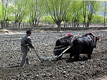
Tibetan farmer ploughing a field with yaks
Main article: Economy of Tibet
The Tibetans traditionally depended upon agriculture for survival. Since the 1980s, however, other jobs such as taxi-driving and hotel retail work have become available in the wake of Chinese economic reform. In 2011, Tibet's nominal GDP topped 60.5 billion yuan (US$9.60 billion), nearly more than seven times as big as the 11.78 billion yuan (US$1.47 billion) in 2000. In the past five years, Tibet's annual GDP growth has averaged 12%.[31]
While traditional agriculture and animal husbandry continue to lead the area's economy, in 2005 the tertiary sector contributed more than half of its GDP growth, the first time it surpassed the area's primary industry.[51][52] Rich reserves of natural resources and raw materials have yet to lead to the creation of a strong secondary sector, due in large part to the province's inhospitable terrain, low population density, an underdeveloped infrastructure and the high cost of extraction.[31]
The collection of caterpillar fungus (Cordyceps sinensis, known in Tibetan as Yartsa Gunbu) in late spring / early summer is in many areas the most important source of cash for rural households. It contributes an average of 40% to rural cash income and 8.5% to the TAR's GDP.[53]
The re-opening of the Nathu La pass (on southern Tibet's border with India) should facilitate Sino-Indian border trade and boost Tibet's economy.[54]
In 2008, Chinese news media reported that the per capita disposable incomes of urban and rural residents in Tibet averaged 12,482 yuan (US$1,798) and 3,176 yuan (US$457) respectively.[55]
The China Western Development policy was adopted in 2000 by the central government to boost economic development in western China, including the Tibet Autonomous Region.

Tourism[edit]

The Potala Palace in Lhasa, the capital of the TAR.
Foreign tourists were first permitted to visit the Tibet Autonomous Region in the 1980s. While the main attraction is the Potala Palacein Lhasa, there are many other popular tourist destinations including the Jokhang TempleNamtso Lake, and Tashilhunpo Monastery.[56] Nonetheless, tourism in Tibet is still restricted for non-Chinese passport holders and Taiwan citizens, and presently the only way for foreigners to enter is via Tibet Entry Permit. The permit can only be obtained through a travel agency in Tibet, and travel in Tibet must be arranged in a group tour, in which the group must be accompanied by a licensed tour guide at all times. Those traveling into Tibet must specify every location they want to travel within the TAR, and thus cannot travel anywhere not specified in the application. Before entering on a train, plane, or road leading into Tibet, anyone without a Chinese passport must present the Tibet Entry Permit, or they will otherwise be denied entry. Even people coming to Tibet from Nepal must have arranged for the entry permit ahead of time. People barred from obtaining the permit are journalists, diplomats, professional media photographers, and government officials.[57]

Transport[edit]

Airports[edit]

The civil airports in Tibet are Lhasa Gonggar Airport,[58] Qamdo Bangda AirportNyingchi Airport, and the Gunsa Airport.
Gunsa Airport in Ngari Prefecture began operations on 1 July 2010, to become the fourth civil airport in China's Tibet Autonomous Region.[59]
The Peace Airport for Xigazê was completed on 30 October 2010.[60]
Nagqu Dagring Airport is expected to become the world's highest altitude airport by 2014 at 4,436 meters above sea level.[61]

Railway[edit]

The Qinghai–Tibet Railway from Golmud to Lhasa was completed on 12 October 2005. It opened to regular trial service on 1 July 2006. Five pairs of passenger trains run between Golmud and Lhasa, with connections onward to Beijing, Chengdu, Chongqing, Guangzhou, Shanghai, Xining and Lanzhou. The line includes the Tanggula Pass, which, at 5,072 m (16,640 ft) above sea level, is the world's highest railway.
The Lhasa–Xigazê Railway branch from Lhasa to Xigazê was completed in 2014. It opened to regular service on 15 August 2014.
The construction of first section of the Sichuan–Tibet Railway from Lhasa to Nyingchi. Construction work is expected to start in November 2014, and to take 7 years.[62]