"San Francisco Earthquake" redirects here. For the 1989 earthquake, see 1989 Loma Prieta earthquake. For the 2014 earthquake, see 2014 South Napa earthquake.
The 1906 San Francisco earthquake struck the coast of Northern California at 5:12 a.m. on April 18 with an estimated "moment magnitude" of 7.8 and a maximum "Mercalli intensity" of "XI" ("Extreme"). Severe shaking was felt from Eureka on the North Coast to the Salinas Valley, an agricultural region to the south of the San Francisco Bay Area of the long vast Central Valley. Devastating fires fueled by broken and twisted underground natural gas supply pipes sparked by downed poles with tangles of overloaded new electric lines, soon broke out in the city that lasted for several days. As a result, about 3,000 people died and over 80% of the city ofSan Francisco was destroyed. The earthquake and resulting fire are remembered as one of the worst and deadliest natural disasters in the history of the United States. The death toll remains the greatest loss of life from a natural disaster in California's history and high in the lists of American urban disasters.
Tectonic setting[edit]
The
San Andreas Fault is a continental
transform fault that forms part of the tectonic boundary between the
Pacific Plate and the
North American Plate. The
strike-slip fault is characterized by mainly lateral motion in a
dextral sense, where the western (Pacific) plate moves northward relative to the eastern (North American) plate. The 1906 rupture propagated both northward and southward for a total of 296 miles (476 km).
[6] This
fault runs the length of California from the
Salton Sea in the south to
Cape Mendocino in the north, a distance of about 810 miles (1,300 km). The maximum observed surface displacement was about 20 feet (6 m);
geodetic measurements show displacements of up to 28 feet (8.5 m).
[7]
Earthquake[edit]
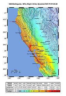
USGS ShakeMap showing the earthquake's intensity.
The 1906 earthquake preceded the development of the
Richter magnitude scale by three decades. The most widely accepted estimate for the magnitude of the quake on the modern
moment magnitude scale is 7.8;
[1] values from 7.7 to as high as 8.3 have been proposed.
[8]According to findings published in the
Journal of Geophysical Research, severe deformations in the earth's crust took place both before and after the earthquake's impact. Accumulated strain on the faults in the system was relieved during the earthquake, which is the supposed cause of the damage along the 450-kilometer-long segment of the San Andreas plate boundary.
[9] The
main shock epicenteroccurred offshore about 2 miles (3.2 km) from the city, near
Mussel Rock. Shaking was felt from
Oregon to Los Angeles, and inland as far as central
Nevada.
[10]
A strong
foreshock preceded the main shock by about 20 to 25 seconds. The strong shaking of the main shock lasted about 42 seconds. There were decades of minor earthquakes – more than at any other time in the historical record for northern California – before the 1906 quake. Widely interpreted previously as precursory activity to the 1906 earthquake, they have been found to have a strong seasonal pattern and have been postulated to be due to large seasonal sediment loads in coastal bays that overlie faults as a result of the erosion caused by
hydraulic mining in the later years of the
California Gold Rush.
[11]
For years, the epicenter of the quake was assumed to be near the town of
Olema, in the
Point Reyes area of
Marin County, because of evidence of the degree of local earth displacement. In the 1960s, a seismologist at
UC Berkeley proposed that the epicenter was more likely offshore of San Francisco, to the northwest of the
Golden Gate. The most recent analysis by the
United States Geological Survey(USGS) shows that the most likely epicenter was very near
Mussel Rock on the coast of
Daly City, an adjacent suburb just south of San Francisco.
[12][better source needed] An offshore epicenter is supported by the occurrence of a local
tsunami recorded by a tide gauge at the
San Francisco Presidio; the wave had an amplitude of approximately 3 in (8 cm) and an approximate period of 40–45 minutes.
[13]
Damaged houses on Howard Street (left), and ruins in the vicinity of Post and Grant Avenue
At the time, 375 deaths were reported,
[14] partly because hundreds of fatalities in
Chinatown went ignored and unrecorded. The total number of deaths is still uncertain today, and is estimated to be roughly 3,000 at minimum.
[15] Most of the deaths occurred in San Francisco itself, but 189 were reported elsewhere in the
Bay Area; nearby cities, such as
Santa Rosa and
San Jose, also suffered severe damage. In
Monterey County, the earthquake permanently shifted the course of the
Salinas River near its mouth. Where previously the river emptied into Monterey Bay between
Moss Landing and
Watsonville, it was diverted 6 miles south to a new channel just north of
Marina.
Between 227,000 and 300,000 people were left homeless out of a population of about 410,000; half of those who evacuated fled across the bay to
Oakland and
Berkeley. Newspapers described
Golden Gate Park, the
Presidio,
the Panhandle and the beaches between
Ingleside and
North Beach as covered with makeshift tents. More than two years later, many of these refugee camps were still in operation.
[16]
The earthquake and fire left long-standing and significant pressures on the development of California. At the time of the disaster, San Francisco had been the ninth-largest city in the United States and the largest on the
West Coast, with a population of about 410,000. Over a period of 60 years, the city had become the financial, trade and cultural center of the
West; operated the busiest port on the West Coast; and was the "gateway to the Pacific", through which growing U.S. economic and military power was projected into the Pacific and Asia. Over 80% of the city was destroyed by the earthquake and fire. Though San Francisco rebuilt quickly, the disaster diverted trade, industry and population growth south to Los Angeles, which during the 20th century became the largest and most important urban area in the West. Many of the city's leading poets and writers retreated to
Carmel-by-the-Sea where, as "The Barness", they established the arts colony reputation that continues today.
The 1908 Lawson Report, a study of the 1906 quake led and edited by Professor Andrew Lawson of the University of California, showed that the same
San Andreas Fault which had caused the disaster in San Francisco ran close to Los Angeles as well. The earthquake was the first natural disaster of its magnitude to be documented by photography and motion picture footage and occurred at a time when the science of
seismology was blossoming. The overall cost of the damage from the earthquake was equivalent to $10,500,000,000 in 2016.
Intensity[edit]
The most important characteristic of the shaking intensity noted in
Andrew Lawson's (1908) report was the clear
correlation of intensity with underlying geologic conditions. Areas situated in
sediment-filled valleys sustained stronger shaking than nearby bedrock sites, and the strongest shaking occurred in areas of former bay where
earthquake liquefactionhad occurred. Modern seismic-zonation practice accounts for the differences in seismic hazard posed by varying geologic conditions.
[17] The shaking intensity as described on the
Modified Mercalli intensity scale reached XI (
Extreme) in San Francisco and areas to the north like
Santa Rosa where destruction was devastating.
Although the impact of the earthquake on San Francisco was the most famous, the earthquake also inflicted considerable damage on several other cities. These include
San Jose and
Santa Rosa, the entire downtown of which was essentially destroyed.
[18][19][20]
As damaging as the earthquake and its
aftershocks were, the fires that burned out of control afterward were even more destructive.
[21] It has been estimated that up to 90% of the total destruction was the result of the subsequent fires.
[22] Within three days,
[23] over 30 fires, caused by ruptured gas mains, destroyed approximately 25,000 buildings on 490 city blocks. One of the largest of these fires was accidentally started in a house on Hayes Street by a woman making breakfast for her family. This came to be known as the "Ham and Eggs Fire". Some were started when
firefighters, untrained in the use of
dynamite, attempted to demolish buildings to create
firebreaks. The dynamited buildings themselves often caught fire. The city's fire chief, Dennis T. Sullivan, who would have been responsible, had died from injuries sustained in the initial quake.
[24] In all, the fires burned for four days and nights.
Due to a widespread practice by
insurers to indemnify San Francisco properties from fire, but not earthquake damage, most of the destruction in the city was blamed on the fires. Some property owners deliberately set fire to damaged properties, in order to claim them on their insurance. Capt. Leonard D. Wildman of the
U.S. Army Signal Corps[25] reported that he "was stopped by a fireman who told me that people in that neighborhood were firing their houses…they were told that they would not get their insurance on buildings damaged by the earthquake unless they were damaged by fire".
[26]
One landmark building lost in the fire was the
Palace Hotel, subsequently rebuilt, which had many famous visitors, including royalty and celebrated performers. It was constructed in 1875 primarily financed by Bank of California co-founder
William Ralston, the "man who built San Francisco". In April 1906, the tenor
Enrico Caruso and members of the
Metropolitan Opera Company came to San Francisco to give a series of performances at the Grand Opera House. The night after Caruso's performance in
Carmen, the tenor was awakened in the early morning in his Palace Hotel suite by a strong jolt. Clutching an autographed photo of President
Theodore Roosevelt, Caruso made an effort to get out of the city, first by boat and then by train, and vowed never to return to San Francisco. Caruso died in 1921, having remained true to his word. The Metropolitan Opera Company lost all of its traveling sets and costumes in the earthquake and ensuing fires.
[27]
Some of the greatest losses from fire were in scientific
laboratories.
Alice Eastwood, the curator of
botany at the
California Academy of Sciences in San Francisco, is credited with saving nearly 1,500 specimens, including the entire type specimen collection for a newly discovered and extremely rare species, before the remainder of the largest botanical collection in the western United States was destroyed in the fire.
[28][29] The entire laboratory and all the records of
Benjamin R. Jacobs, a
biochemist who was researching the nutrition of everyday foods, were destroyed.
[30] Another treasure destroyed in the fires was the original California flag used in the 1846
Bear Flag Revolt at
Sonoma, which at the time was being stored in a state building in San Francisco.
[31]
Response[edit]
The city's fire chief, Dennis T. Sullivan, was gravely injured when the earthquake first struck and later died from his injuries. The interim fire chief sent an urgent request to the
Presidio, an army post on the edge of the stricken city, for
dynamite. General
Frederick Funston had already decided that the situation required the use of troops. Telephoning a policeman, he sent word to Mayor Eugene Schmitz of his decision to assist, and then ordered army troops from nearby
Angel Island to mobilize and come into the city. Explosives were ferried across the bay from the California Powder Works in what is now
Hercules.

Soldiers looting during the fire
During the first few days, soldiers provided valuable services like patrolling streets to discourage looting and guarding buildings such as the
U.S. Mint, post office, and county jail. They aided the fire department in dynamiting to demolish buildings in the path of the fires. The army also became responsible for feeding, sheltering, and clothing the tens of thousands of displaced residents of the city. Under the command of Funston's superior, Major General
Adolphus Greely, Commanding Officer, Pacific Division, over 4,000 troops saw service during the emergency. On July 1, 1906, civil authorities assumed responsibility for relief efforts, and the army withdrew from the city.
On April 18, in response to riots among evacuees and looting, Mayor Schmitz issued and ordered posted a proclamation that "The Federal Troops, the members of the Regular
Police Force and all Special Police Officers have been authorized by me to kill any and all persons found engaged in Looting or in the Commission of Any Other Crime".
[32] In addition, accusations of soldiers themselves engaging in looting also surfaced.
[33]
Early on April 18, 1906, recently retired Captain
Edward Ord of the
22nd Infantry Regiment was appointed a Special Police Officer by Mayor Eugene Schmitz and liasioned with Major General Adolphus Greely for relief work with the 22nd Infantry and other military units involved in the emergency. Ord later wrote a long letter
[34] to his mother on the April 20 regarding Schmitz' "Shoot-to-Kill" Order and some "despicable" behavior of certain soldiers of the 22nd Infantry who were looting. He also made it clear that the majority of soldiers served the community well.
[33]
Aftermath[edit]
Property losses from the disaster have been estimated to be more than $400 million.
[35] An insurance industry source tallies insured losses at $235 million, the equivalent to $6.19 billion in 2015 dollars.
[36][37]

Refugees leaving the city
Political and business leaders strongly downplayed the effects of the earthquake, fearing loss of outside investment in the city which badly needed to rebuild.
[38] In his first public statement, California governor
George Pardee emphasized the need to rebuild quickly: "This is not the first time that San Francisco has been destroyed by fire, I have not the slightest doubt that the City by the Golden Gate will be speedily rebuilt, and will, almost before we know it, resume her former great activity".
[39] The earthquake itself is not even mentioned in the statement. Fatality and monetary damage estimates were manipulated.
[40]
Almost immediately after the quake (and even during the disaster), planning and reconstruction plans were hatched to quickly rebuild the city. Rebuilding funds were immediately tied up by the fact that virtually all the major banks had been sites of the conflagration, requiring a lengthy wait of seven-to-ten days before their fire-proof vaults could cool sufficiently to be safely opened. The Bank of Italy had evacuated its funds and was able to provide liquidity in the immediate aftermath. Its president also immediately chartered and financed the sending of two ships to return with shiploads of lumber from Washington and Oregon mills which provided the initial reconstruction materials and surge. In 1929, Bank of Italy was renamed and is now known as
Bank of America.
William James, the pioneering American psychologist, was teaching at Stanford at the time of the earthquake and traveled into San Francisco to observe first-hand its aftermath. He was most impressed by the positive attitude of the survivors and the speed with which they improvised services and created order out of chaos.
[41] This formed the basis of the chapter "On some Mental Effects of the Earthquake" in his book
Memories and Studies.
[42]
H. G. Wells had just arrived in New York on his first visit to America when he learned, at lunch, of the San Francisco earthquake. What struck him about the reaction of those around him was that "it does not seem to have affected any one with a sense of final destruction, with any foreboding of irreparable disaster. Every one is talking of it this afternoon, and no one is in the least degree dismayed. I have talked and listened in two clubs, watched people in cars and in the street, and one man is glad that Chinatown will be cleared out for good; another's chief solicitude is for
Millet's 'Man with the Hoe.' 'They'll cut it out of the frame,' he says, a little anxiously. 'Sure.' But there is no doubt anywhere that San Francisco can be rebuilt, larger, better, and soon. Just as there would be none at all if all this New York that has so obsessed me with its limitless bigness was itself a blazing ruin. I believe these people would more than half like the situation."
[43]
The grandeur of citywide reconstruction schemes required investment from Eastern monetary sources, hence the spin and de-emphasis of the earthquake, the promulgation of the tough new building codes, and subsequent reputation sensitive actions such as the official low death toll. One of the more famous and ambitious plans came from famed urban planner
Daniel Burnham. His bold plan called for, among other proposals,
Haussmann-style avenues, boulevards,
arterial thoroughfares that radiated across the city, a massive civic center complex with classical structures, and what would have been the largest urban park in the world, stretching from
Twin Peaks to
Lake Merced with a large
atheneum at its peak. But this plan was dismissed during the aftermath of the earthquake.
For example, real estate investors and other land owners were against the idea due to the large amount of land the city would have to purchase to realize such proposals.
[44] City fathers likewise attempted at the time to eliminate the Chinese population and export
Chinatown (and other poor populations) to the edge of the county where the Chinese could still contribute to the local taxbase.
[45] The Chinese occupants had other ideas and prevailed instead. Chinatown was rebuilt in the newer, modern, Western form that exists today. The destruction of
City Hall and the Hall of Records enabled thousands of Chinese immigrants to claim residency and citizenship, creating a backdoor to the
Chinese Exclusion Act, and
bring in their relatives from China.
[46][47][48]
The earthquake was also responsible for the development of the
Pacific Heights neighborhood. The immense power of the earthquake had destroyed almost all of the mansions on
Nob Hill except for the
James C. Flood Mansion. Others that hadn't been destroyed were dynamited by the Army forces aiding the firefighting efforts in attempts to create firebreaks. As one indirect result, the wealthy looked westward where the land was cheap and relatively undeveloped, and where there were better views and a consistently warmer climate. Constructing new mansions without reclaiming and clearing old rubble simply sped attaining new homes in the tent city during the reconstruction. In the years after the first world war, the "money" on Nob Hill migrated to Pacific Heights, where it has remained to this day.
Since 1915, the city has officially commemorated the disaster each year by gathering the remaining survivors at
Lotta's Fountain, a fountain in the city's
financial district that served as a meeting point during the disaster for people to look for loved ones and exchange information.
Housing[edit]

One of the eleven housing camps
The army built 5,610
redwood and
fir "relief houses" to accommodate 20,000 displaced people. The houses were designed by
John McLaren, and were grouped in eleven camps, packed close to each other and rented to people for two dollars per month until rebuilding was completed. They were painted olive drab, partly to blend in with the site, and partly because the military had large quantities of olive drab paint on hand. The camps had a peak population of 16,448 people, but by 1907 most people had moved out. The camps were then re-used as garages, storage spaces or shops. The cottages cost on average $100 to put up. The $2 monthly rents went towards the full purchase price of $50. Most of the shacks have been destroyed, but a small number survived. One of the modest 720 sq ft (67 m
2) homes was purchased in 2006 for more than $600,000.
[49] The last official refugee camp was closed on June 30, 1908.
[50]
During the first few days after news of the disaster reached the rest of the world, relief efforts reached over $5,000,000.
[51] London raised hundreds of thousands of dollars. Individual citizens and businesses donated large sums of money for the relief effort:
Standard Oil gave $100,000;
Andrew Carnegie gave $100,000; the Dominion of Canada made a special appropriation of $100,000 and even the
Bank of Canada in Toronto gave $25,000.
[51] The U.S. government quickly voted for one million dollars in relief supplies which were immediately rushed to the area, including supplies for food kitchens and many thousands of tents that city dwellers would occupy the next several years.
[52] These relief efforts were not enough to get families on their feet again, and consequently the burden was placed on wealthier members of the city, who were reluctant to assist in the rebuilding of homes they were not responsible for. All residents were eligible for daily meals served from a number of communal soup kitchens and citizens as far away as Idaho and Utah were known to send daily loaves of bread to San Francisco as relief supplies were coordinated by the railroads.
[53]
Insurance payments[edit]
Insurance companies, faced with staggering claims of $250 million,
[54] paid out between $235 million and $265 million on policyholders' claims, often for fire damage only, since shake damage from earthquakes was excluded from coverage under most policies.
[55][56] At least 137 insurance companies were directly involved and another 17 as reinsurers.
[57] Twenty companies went bankrupt, and most excluded shake damage claims.
[56] Lloyd's of London reports having paid all claims in full, more than $50 million
[58]and the insurance companies in
Hartford, Connecticut report also paying every claim in full, with the
Hartford Fire Insurance Company paying over $11 million and
Aetna Insurance Company almost $3 million.
[56]
After the 1906 earthquake, a global discussion arose concerning a legally flawless exclusion of the earthquake hazard from fire insurance contracts. It was pressed ahead mainly by re-insurers. Their aim was the globally uniform solution of the problem of earthquake hazard in fire insurance contracts. Until 1910, a few countries, especially in Europe, followed the call for an exclusion of the earthquake hazard from all fire insurance contracts. In the U.S., the question was discussed differently. But the traumatized public reacted with fierce opposition. On August 1, 1909, the
California Senate enacted the California Standard Form of Fire Insurance Policy, which did not contain any earthquake clause. Thus the state decided that insurers would have to pay again if another earthquake was followed by fires. Other earthquake-endangered countries followed the California example.
[59] The insurance payments heavily affected the international financial system. Gold transfers from European insurance companies to policyholders in San Francisco led to a rise in interest rates, subsequently to a lack of available loans and finally to the
Knickerbocker Trust Company crisis of October 1907 which led to the
Panic of 1907.
[60]
Centennial commemorations[edit]
The 1906 Centennial Alliance
[61] was set up as a clearing-house for various centennial events commemorating the earthquake. Award presentations, religious services, a National Geographic TV movie,
[62] a projection of fire onto the Coit Tower,
[63] memorials, and lectures were part of the commemorations. The
USGS Earthquake Hazards Program issued a series of Internet documents,
[64] and the tourism industry promoted the 100th anniversary as well.
[65]
Eleven survivors of the 1906 earthquake attended the centennial commemorations in 2006, including Irma Mae Weule (May 11, 1899 – August 8, 2008),
[66] who was the oldest survivor of the quake at the time of her death in August 2008, aged 109.
[67] Vivian Illing (December 25, 1900 – January 22, 2009) was believed to be the second-oldest survivor at the time of her death, aged 108, leaving Herbert Hamrol (January 10, 1903 – February 4, 2009) as the last known remaining survivor at the time of his death, aged 106. Another survivor, Libera Armstrong (September 28, 1902 – November 27, 2007), attended the 2006 anniversary, but died in 2007, aged 105.
[68]
Shortly after Hamrol's death, two additional survivors were discovered. William Del Monte, then 103, and Jeanette Scola Trapani (April 21, 1902 – December 28, 2009),
[69] 106, stated that they stopped attending events commemorating the earthquake when it became too much trouble for them.
[70] Del Monte and another survivor, Rose Cliver, then 106, attended the earthquake reunion celebration on April 18, 2009, the 103rd anniversary of the earthquake.
[71] Cliver (October 9, 1902 – February 18, 2012)
[72] died in February 2012, aged 109. Nancy Stoner Sage (February 19, 1905 – April 15, 2010) died, aged 105, in
Colorado just three days short of the 104th anniversary of the earthquake on April 18, 2010. Del Monte attended the event at Lotta's Fountain on April 18, 2010 and the dinner at John's Restaurant the night before.
[73] 107-year-old George Quilici (April 26, 1905 – May 31, 2012) died in May 2012.,
[74] and 113-year-old Margaret Ruth Newman (September 23, 1901 – July 29, 2015) in July 2015,
[75] William Del Monte (January 22, 1906 - January 11, 2016), who died in January 2016 at age 109, was thought to be the last survivor.
[76]
Panoramas[edit]
San Francisco burning in 1906.
San Francisco 360° panorama showing damage, 1906
Panoramic view of earthquake and fire damage from Stanford Mansion site, April 18–21, 1906. Note the ruins of the original
City Hall building at far right.
[78]
See also[edit]
| San Francisco Bay Area portal |
| Disasters portal |


