
Map of Pangaea with modern continental outlines
Pangaea or
Pangea (
[1]) was a
supercontinent that existed during the late
Paleozoic and early
Mesozoic eras.
[2][3] It assembled from earlier continental units approximately 335 million years ago, and it began to break apart about 175 million years ago.
[4] In contrast to the present
Earth and its distribution of continental mass, much of Pangaea was in the
southern hemisphere and surrounded by a superocean,
Panthalassa. Pangaea was the most recent supercontinent to have existed and the first to be reconstructed by geologists.
Origin of the concept
-4500 —
–
-4000 —
–
-3500 —
–
-3000 —
–
-2500 —
–
-2000 —
–
-1500 —
–
-1000 —
–
-500 —
–
0 —
The name "Pangaea/Pangea" is derived from
Ancient Greek pan (
πᾶν, "all, entire, whole") and
Gaia (
Γαῖα, "
Mother Earth, land").
[5][10] The concept that the continents once formed a continuous land mass was first proposed by
Alfred Wegener, the originator of the theory of
continental drift, in his 1912 publication
The Origin of Continents (
Die Entstehung der Kontinente).
[11] He expanded upon his hypothesis in his 1915 book
The Origin of Continents and Oceans (
Die Entstehung der Kontinente und Ozeane), in which he postulated that, before breaking up and drifting to their present locations, all the continents had formed a single
supercontinent that he called the "
Urkontinent".
The name "Pangea" occurs in the 1920 edition of
Die Entstehung der Kontinente und Ozeane, but only once, when Wegener refers to the ancient supercontinent as "the Pangaea of the Carboniferous".
[12] Wegener used the Germanized form "Pangäa", but the name entered German and English scientific literature (in 1922
[13] and 1926, respectively) in the Latinized form "Pangaea" (of the Greek "Pangaia"), especially due to a symposium of the American Association of Petroleum Geologists in November 1926.
[14]
Formation
The forming of supercontinents and their breaking up appears to have been
cyclical through Earth's history. There may have been
many others before Pangaea. The fourth-last supercontinent, called
Columbia or Nuna, appears to have assembled in the period 2.0–1.8
Ga.[15][16] Columbia/Nuna broke up and the next supercontinent,
Rodinia, formed from the
accretion and assembly of its fragments. Rodinia lasted from about 1.1 billion years ago (Ga) until about 750 million years ago, but its exact configuration and geodynamic history are not nearly as well understood as those of the later supercontinents, Pannotia and Pangaea.
When Rodinia broke up, it split into three pieces: the supercontinent of
Proto-Laurasia, the supercontinent of
Proto-Gondwana, and the smaller
Congo craton. Proto-Laurasia and Proto-Gondwana were separated by the
Proto-Tethys Ocean. Next
Proto-Laurasia itself split apart to form the continents of
Laurentia,
Siberia and
Baltica. Baltica moved to the east of Laurentia, and Siberia moved northeast of Laurentia. The splitting also created two new oceans, the
Iapetus Ocean and
Paleoasian Ocean. Most of the above masses coalesced again to form the relatively short-lived supercontinent of
Pannotia. This supercontinent included large amounts of land near the poles and, near the equator, only a relatively small strip connecting the polar masses. Pannotia lasted until 540 Ma, near the beginning of the
Cambrian period and then broke up, giving rise to the continents of
Laurentia,
Baltica, and the southern supercontinent of
Gondwana.
In the
Cambrian period, the continent of
Laurentia, which would later become
North America, sat on the
equator, with three bordering oceans: the
Panthalassic Oceanto the north and west, the
Iapetus Ocean to the south and the
Khanty Ocean to the east. In the Earliest
Ordovician, around 480 Ma, the microcontinent of
Avalonia – a landmass incorporating fragments of what would become eastern
Newfoundland, the southern
British Isles, and parts of
Belgium, northern
France,
Nova Scotia,
New England, South
Iberia and northwest Africa – broke free from Gondwana and began its journey to
Laurentia.
[17] Baltica, Laurentia, and Avalonia all came together by the end of the Ordovician to form a minor supercontinent called
Euramerica or Laurussia, closing the Iapetus Ocean. The collision also resulted in the formation of the northern
Appalachians.
Siberia sat near Euramerica, with the
Khanty Ocean between the two continents. While all this was happening, Gondwana drifted slowly towards the South Pole. This was the first step of the formation of Pangaea.
[18]
The second step in the formation of Pangaea was the collision of Gondwana with
Euramerica. By
Silurian time, 440 Ma, Baltica had already collided with Laurentia, forming Euramerica.
Avalonia had not yet collided with
Laurentia, but as Avalonia inched towards Laurentia, the seaway between them, a remnant of the
Iapetus Ocean, was slowly shrinking. Meanwhile,
southern Europe broke off from Gondwana and began to move towards Euramerica across the newly formed
Rheic Ocean. It collided with southern
Baltica in the
Devonian, though this microcontinent was an underwater plate. The Iapetus Ocean's sister ocean, the Khanty Ocean, shrank as an island arc from Siberia collided with eastern Baltica (now part of Euramerica). Behind this
island arc was a new ocean, the
Ural Ocean.
Western
Kazakhstania collided with
Baltica in the Late Carboniferous, closing the
Ural Ocean between them and the western Proto-Tethys in them (
Uralian orogeny), causing the formation of not only the
Ural Mountains but also the supercontinent of Laurasia. This was the last step of the formation of Pangaea. Meanwhile, South America had collided with southern
Laurentia, closing the
Rheic Ocean and forming the southernmost part of the
Appalachians and
Ouachita Mountains. By this time, Gondwana was positioned near the South Pole and glaciers were forming in Antarctica, India, Australia, southern Africa and South America. The
North China block collided with
Siberia by Late Carboniferous time, completely closing the Proto-Tethys Ocean.
By early
Permian time, the
Cimmerian plate split from
Gondwana and headed towards Laurasia, thus closing the
Paleo-Tethys Ocean, but forming a new ocean, the
Tethys Ocean, in its southern end. Most of the landmasses were all in one. By the
Triassic Period, Pangaea rotated a little and the Cimmerian plate was still travelling across the shrinking Paleo-Tethys, until the
Middle Jurassic time. The Paleo-Tethys had closed from west to east, creating the
Cimmerian Orogeny. Pangaea, which looked like a
C, with the new Tethys Ocean inside the
C, had rifted by the Middle Jurassic, and its deformation is explained below.
Evidence of existence
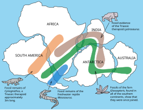
The distribution of fossils across the continents is one line of evidence pointing to the existence of Pangaea.
Fossil evidence for Pangaea includes the presence of similar and identical species on continents that are now great distances apart. For example, fossils of the
therapsid Lystrosaurus have been found in
South Africa,
India and
Antarctica, alongside members of the
Glossopteris flora, whose distribution would have ranged from the polar circle to the equator if the continents had been in their present position; similarly, the freshwater reptile
Mesosaurus has been found in only localized regions of the coasts of
Brazil and
West Africa.
[19]
Additional evidence for Pangaea is found in the
geology of adjacent continents, including matching geological trends between the eastern coast of
South America and the western coast of
Africa. The
polar ice cap of the
CarboniferousPeriod covered the southern end of Pangaea. Glacial deposits, specifically
till, of the same age and structure are found on many separate continents which would have been together in the continent of Pangaea.
[20]
Paleomagnetic study of apparent polar wandering paths also support the theory of a supercontinent. Geologists can determine the movement of continental plates by examining the orientation of magnetic minerals in rocks; when rocks are formed, they take on the magnetic properties of the Earth and indicate in which direction the poles lie relative to the rock. Since the magnetic poles
drift about the rotational pole with a period of only a few thousand years, measurements from numerous lavas spanning several thousand years are averaged to give an apparent mean polar position. Samples of
sedimentary rock and
intrusive igneous rock have magnetic orientations that are typically an average of the "secular variation" in the orientation of
magnetic north because their
remanent magnetizations are not acquired instantaneously. Magnetic differences between sample groups whose age varies by millions of years is due to a combination of
true polar wander and the drifting of continents. The true polar wander component is identical for all samples, and can be removed, leaving geologists with the portion of this motion that shows continental drift and can be used to help reconstruct earlier continental positions.
[21]
The continuity of mountain chains provides further evidence for Pangaea. One example of this is the
Appalachian Mountains chain which extends from the southeastern
United States to the
Caledonides of Ireland, Britain, Greenland, and Scandinavia.
[22]
Rifting and break-up

Animation of the rifting of Pangaea
There were three major phases in the break-up of Pangaea. The first phase began in the
Early-
Middle Jurassic (about 175 Ma), when Pangaea began to rift from the Tethys Ocean in the east to the
Pacific in the west. The rifting that took place between North America and Africa produced multiple
failed rifts. One rift resulted in a new ocean, the North
Atlantic Ocean.
[22]
The Atlantic Ocean did not open uniformly; rifting began in the north-central Atlantic. The
South Atlantic did not open until the
Cretaceous when Laurasia started to rotate clockwise and moved northward with North America to the north, and
Eurasia to the south. The clockwise motion of Laurasia led much later to the closing of the
Tethys Ocean. Meanwhile, on the other side of Africa and along the adjacent margins of east Africa, Antarctica and
Madagascar, new rifts were forming that would lead to the formation of the southwestern
Indian Ocean that would open up in the Cretaceous.
The second major phase in the break-up of Pangaea began in the
Early Cretaceous (150–140 Ma), when the minor supercontinent of Gondwana separated into multiple continents (Africa, South America, India, Antarctica, and Australia). The subduction at
Tethyan Trench probably caused Africa, India and Australia to move northward, causing the opening of a "South Indian Ocean". In the Early Cretaceous,
Atlantica, today's South America and Africa, finally separated from eastern Gondwana (Antarctica, India and Australia). Then in the Middle Cretaceous, Gondwana fragmented to open up the South Atlantic Ocean as South America started to move westward away from Africa. The South Atlantic did not develop uniformly; rather, it rifted from south to north.
Also, at the same time,
Madagascar and India began to separate from Antarctica and moved northward, opening up the Indian Ocean. Madagascar and India separated from each other 100–90 Ma in the Late Cretaceous. India continued to move northward toward Eurasia at 15 centimeters (6 in) a year (a plate tectonic record), closing the eastern Tethys Ocean, while Madagascar stopped and became locked to the
African Plate.
New Zealand,
New Caledonia and the rest of
Zealandiabegan to separate from Australia, moving eastward toward the
Pacific and opening the
Coral Sea and
Tasman Sea.
The third major and final phase of the break-up of Pangaea occurred in the early
Cenozoic (
Paleocene to
Oligocene).
Laurasia split when North America/Greenland (also called
Laurentia) broke free from Eurasia, opening the
Norwegian Sea about 60–55 Ma. The Atlantic and Indian Oceans continued to expand, closing the Tethys Ocean.
Meanwhile, Australia split from Antarctica and moved quickly northward, just as India had done more than 40 million years before. Australia is currently on a collision course with
eastern Asia. Both Australia and India are currently moving northeast at 5–6 centimeters (2–3 in) a year. Antarctica has been near or at the South Pole since the formation of Pangaea about 280 Ma. India started to collide with
Asia beginning about 35 Ma, forming the
Himalayan orogeny, and also finally closing the
Tethys Seaway; this collision continues today. The African Plate started to change directions, from west to northwest toward
Europe, and South America began to move in a northward direction, separating it from Antarctica and allowing complete oceanic circulation around Antarctica for the first time. This motion, together with decreasing atmospheric
carbon dioxide concentrations, caused a rapid cooling of Antarctica and allowed
glaciers to form. This glaciation eventually coalesced into the kilometers-thick ice sheets seen today.
[23] Other major events took place during the
Cenozoic, including the opening of the
Gulf of California, the uplift of the
Alps, and the opening of the
Sea of Japan. The break-up of Pangaea continues today in the
Red Sea Rift and
East African Rift.
Tectonic plate shift

The breakup of Pangaea over time
Pangaea's formation is now commonly explained in terms of
plate tectonics. The involvement of plate tectonics in Pangaea's
[24]separation helps to show how it did not separate all at once, but at different times, in sequences. Additionally, after these separations, it has also been discovered that the separated land masses may have also continued to break apart multiple times. The formation of each
environment and climate on Pangaea is due to plate tectonics, and thus, it is as a result of these shifts and changes different climatic pressures were placed on the life on Pangaea. Although plate tectonics was paramount in the formation of later land masses, it was also essential in the placement, climate, environments, habitats, and overall structure of Pangaea.
[25]
What can also be observed in relation to tectonic plates and Pangaea, is the formations to such plates. Mountains and valleys form due to tectonic collisions as well as earthquakes and chasms. Consequentially, this shaped Pangaea and animal
adaptations. Furthermore, plate tectonics can contribute to
volcanic activity,
[26] which is responsible for extinctions and adaptations which have evidently affected life over time, and without doubt on Pangaea.
Life
For the approximately 160 million years Pangaea existed, many species had fruitful times whereas others struggled. The
Traversodontidae[27] is an example of such prospering animals, eating a diet of only plants. Plants dependent on
sporereproduction had been taken out of the
ecosystems, and replaced by the
gymnosperm plant, which reproduces through the use of seeds instead. Later on, insects (beetles, dragonflies, mosquitos) also thrived during the
Permian period 299 to 252 million years ago.
[28] However, the
Permian extinction at 252 Mya greatly impacted these insects in mass extinction, being the only mass extinction to affect insects. When the
Triassic Period came, many reptiles were able to also thrive, including Archosaurs, which were an ancestor to modern-day crocodiles and birds.
Little is known about marine life during the existence of Pangaea. Scientists are unable to find substantial evidence or fossilized remains in order to assist them in answering such questions. However, a couple of marine animals have been determined to have existed at the time- the
Ammonites and
Brachiopods. Additionally, evidence pointing towards massive reefs with varied ecosystems, especially in the species of sponges and coral, have also been discovered.
[citation needed]
Climate change after Pangaea
Pangaea has tremendously affected the setup of the world now. We live in a post Pangaea time period where the reconfiguration of continents and oceans has changed the climate of many areas. There is scientific evidence that proves that climate was drastically altered. When the continents separated and reformed themselves, it changed the flow of the oceanic currents and winds. The scientific reasoning behind all of the changes is
Continental Drift. The theory of Continental Drift, created by
Alfred Wegener, explained how the continents shifted Earth’s surface and how that affected many aspects such as climate, rock formations found on different continents and plant and animal fossils.
[29] Wegener studied plant fossils from the frigid Arctic of
Svalbard,
Norway. He determined that such plants were not meant to adapt to a glacial climate. The fossils he found were from tropical plants that were meant to adapt and thrive in warmer and tropical climate.
[30] Because we would not assume that the plant fossils were capable of traveling to a different place we suspect that Svalbard possibly had a warmer, less frigid climate in the past.
[31]
When Pangaea separated, the reorganization of the continents changed the function of the oceans and seaways. The restructuring of the continents, changed and altered the distribution of warmth and coolness of the oceans. When North America and South America connected, it stopped equatorial currents from passing from the Atlantic Ocean to the Pacific Ocean.
[32] Researchers have found evidence by using computer hydrological models to show that this strengthened the Gulf Stream by diverting more warm currents towards Europe. Warm waters at high latitudes led to an increased evaporation and eventually atmospheric moisture. Increased evaporation and atmospheric moisture resulted in increased precipitation. Evidence of increased precipitation is the development of snow and ice that covers Greenland, which led to an accumulation of the icecap. Greenland’s growing ice cap led to further
global cooling.
[32] Scientists also found evidence of global cooling through the separation of Australia and Antarctica and the formation of the Antarctic Ocean. Ocean currents in the newly formed Antarctic or Southern Ocean created a circumpolar current.
[32] The creation of the new ocean that caused a circumpolar current eventually led to atmospheric currents that rotated from west to east. Atmospheric and oceanic currents stopped the transfer of warm, tropical air and water to the higher latitudes. As a result of the warm air and currents moving northward, Antarctica cooled down so much that it became frigid.
Although many of Alfred Wegener’s theories and conclusions were valid, scientists are constantly coming up with new innovative ideas or reasoning behind why certain things happen. Wegener’s theory of Continental Drift was later replaced by the theory of
tectonic plates.
[33]
Implications of extinction
There is evidence to suggest that the deterioration of northern Pangaea contributed to the
Permian Extinction, one of Earth’s five major mass extinction events, which resulted in the loss of over 90% of marine and 70% of terrestrial species. There were three main sources of environmental deterioration which are believed to have had a hand in the extinction event.
The first of these sources is a loss of oxygen concentration in the ocean which caused deep water regions called the
lysocline to grow shallower. With the lysocline shrinking, there were fewer places for
calcite to dissolve in the ocean, considering calcite only dissolves at deep ocean depths. This led to the extinction of
carbonateproducers such as
brachiopods and
corals that relied on dissolved calcite to survive. The second source is the eruption of the
Siberian Traps, a large volcanic event which is argued to be the result of Pangaean tectonic movement.
[34] This had several negative repercussions on the environment, including metal loading and excess atmospheric carbon. Metal loading, the release of toxic metals from volcanic eruptions into the environment, led to
acid rain and general stress on the environment. These toxic metals are known to infringe on
vascular plants’ ability to
photosynthesize, which may have resulted in the loss of Permian-era flora. Excess
carbon dioxidein the atmosphere is believed to be the main cause of the shrinking of lysocline areas.
The third cause of this extinction event that can be attributed to northern Pangaea is the beginnings of anoxic ocean environments, or oceans with very low oxygen concentrations. The mix of
anoxic oceans and
ocean acidification due to metal loading led to increasingly acidic oceans,
[35] which ultimately led to the extinction of benthic species.
[36]


